Overview
Thunderstruck's 100% owned Liwa epithermal/porphyry prospect features four high-grade precious metals targets over a 3 km structural corridor and is open in all directions. Comprehensive geochemical and geophysical campaigns by the Company resulted in the discovery of numerous zones of alteration returning anomalous soil, outcrop, float and trench gold grades with coincident geophysical anomalies at depth.
Location
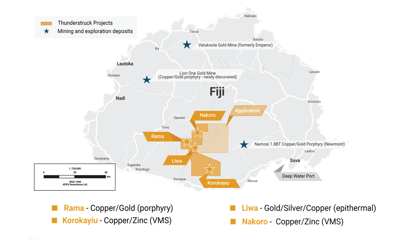
The Liwa prospect is located on the southern part of Fiji’s largest island, Viti Levu, which hosts two operating gold mines, Tuvatu and Vatakoula. Liwa is approximately 60 kilometers northwest of the deep-water port and capital of Suva. It lies 6 km southeast of Thunderstruck’s Rama copper/gold porphyry and may represent part of the same large copper/gold system.
Geology and mineralization
Fiji was borne in a Miocene island arc setting where the Pacific oceanic plate was actively
subducting beneath the Australian plate along the Tonga Trench. With the opening of the inter-arc Lau Basin at about 5 Ma b.p., the Tonga trench and its related subduction zone migrated to the east away from Fiji leaving the island group stranded between the Tonga and Vanuatu subduction zones. As a result, Fiji experienced a significant decrease in andesitic arc volcanism and a transition to predominantly tholeiitic basaltic volcanism. Fiji is now stranded on the Lau-Colville Ridge, a remnant arc and is thereby spared the volatile-rich explosive volcanism that characterizes much of the Pacific Rim.
The highly potassic chemistry and the coexistence of plagioclase and sanidine of the Fijian volcanic rocks attests to the shoshonite association of these assemblages. In turn, this chemistry is consistent with that of many of the major epithermal and porphyry deposits found in the Pacific region. The present day Tavua Volcano in Viti Levu is shoshonitic, initially developing as a seafloor volcano and then emerging as the mountain grew,
primarily constructed by olivene-bearing alkaline basalt flows, with debris flows and conglomerates on its flanks.
Like all other epithermal gold districts globally, the potential for significant epithermal gold in Fiji is commensurate with its location on a major plutonic/volcanic arc. These deposits are prevalent in the so-called circum-Pacific ‘Ring of Fire’ as well as in the convergent Mediterranean-Balkans-Tethyan orogenic belts. Isolated examples of older epithermal deposits, such as the neo-Proterozoic Mahd adh Dhahab gold mine in Saudi Arabia, attest to the development of ancient island arc setting during the assembly and suturing of shield terranes. Evidence of Fiji’s potential for significant epithermal gold mineralization was heralded by the discovery of the Vatukoula (formerly Emperor) Mine in 1932, which is still in operation.
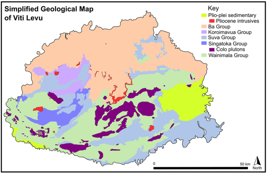
Recent studies at Liwa confirm that the observed mineralization styles represent an intermediate (+/‐ high) sulphidation style epithermal gold‐silver deposit. It is proposed that mineralization is related to the intrusion of the Tholo Plutonic Suite. Gold‐silver, locally base metal‐rich bearing veins and broad hydrothermal alteration zones are hosted primarily within basaltic trachyte/andesite rocks of the Wainimala Group (Figure 1).
Mineralization is controlled by northeast‐trending fault zones and is spatially related to kaolinite‐poor argillic alteration present in two forms - thin, base metal sulphide‐silver veins, and two‐stage breccias with acid argillic altered cores and argillically altered peripheries that host gold mineralization in the form of electrum.
Significantly, open‐space veining and silicic alteration at higher elevations are interpreted to indicate that current exposure lies close to the paleo water table and has seen relatively little erosion, indicating that considerable potential exists in structures open along strike and at depth.
Figure 1: Geological Map of Viti Levu, Fiji. Liwa is hosted in the Wainimala Group
History
In the late 1970s, Amoco Minerals discovered 8.4 g/t gold and 93 g/t silver within a siliceous float sample. However, no systematic exploration was done by them or others in the ensuing 50 years until Thunderstruck recently discovered Liwa’s significant precious metals potential in 2018.
Thunderstruck Exploration History
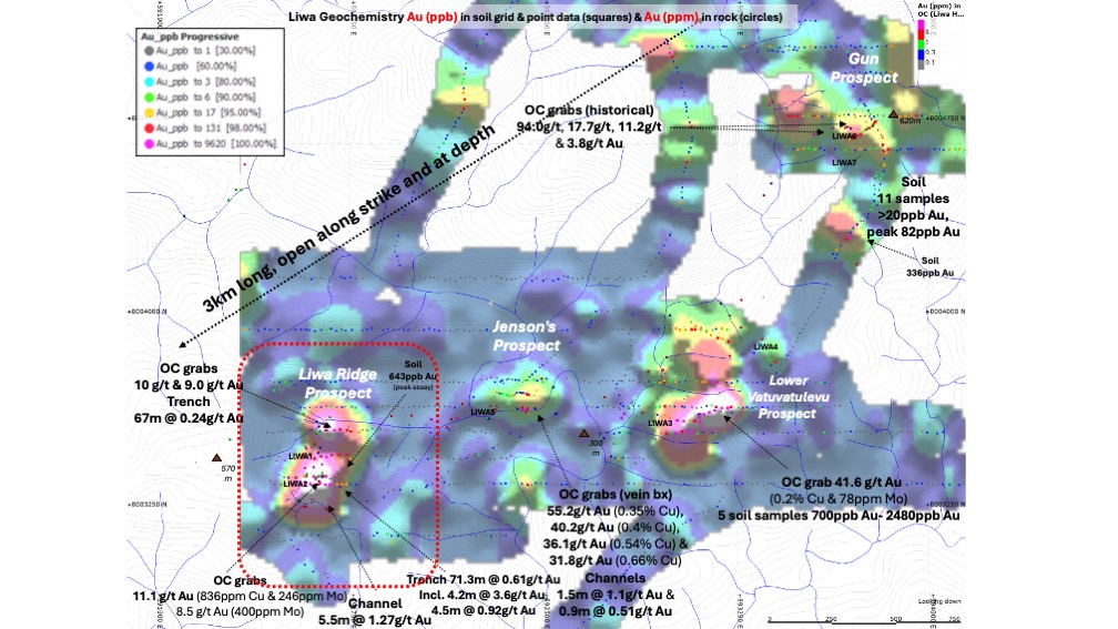
Comprehensive geochemical and geophysical exploration campaigns along with two exploratory drill holes, discovered four main prospects along an approximately 3 km northeast‐southwest oriented structural corridor (See Figure 2).
Highlights of the four targets include:
Liwa Ridge
- Trenching returned 0.61 g/t Au over 71 m including 1.2 g/t Au over 26m, with float samples up to 11 g/t Au
- IP geophysics - a zone of high resistivity appears at a depth of approximately 100 m with fringing zones of elevated chargeability with highest chargeability near surface as a mantle over the resistive zone
- High chargeability is spatially associated with gold values at surface
Lower Vatuvatulevu
- 150-meter-wide zone of gold-silver anomalies at surface, including up to 2.5g/t Au in soils, 41.6 g/t Au and 1,205 g/t Ag in rock chips with coincident resistivity and chargeability geophysical anomalies at depths below 150-200m
- One 247.9m drill hole completed with results indicating a likely subvertical to steeply east dipping geometry to the gold-silver zone, follow-up drilling recommended to the west to definitively test the target
Jensen’s
- Well-developed subvertical zone with IP survey showing strong resistivity and high chargeability to a depth of at least 300m below an outcrop that produced surface samples up to 55 g/t Au with up to .67% Cu
- Trench of 5.7 g/t Au over 7 m, one hole drilled hitting 1.74 g/t at 37m
- Drill targets delineated over discrete strong IP resistivity anomaly coincident with anomalous Au and Cu surface expression
Gun
- Possible Cu/Au porphyry at depth based on discrete IP chargeability anomaly coincident with surface sampling up to 11.1g/t Au
Figure 2: Liwa Geochemistry - Gold and Copper mineralization
Geophysics
Induced Polarization Survey
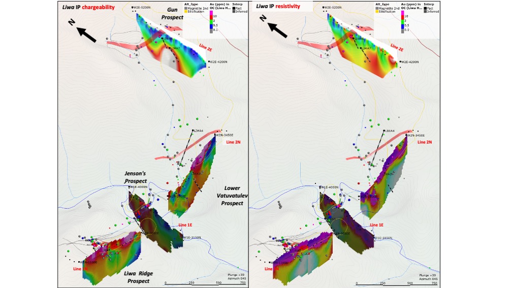
A total of 4 line km’s of induced polarity and resistivity (IP) survey was completed highlighting prospective targets previously defined be geochemical surveys (See Figure 3). Liwa Ridge, Jensen’s, Lower Vatuvatulevu and Gun prospects were surveyed with two east-west and two north-south oriented survey lines.
The presence of strong resistive and coincident weak to moderate chargeability anomalies are interpreted to indicate the presence of silicified lithologies and potentially mineralized targets at depth. Importantly, all four of the prospect showings produce clearly defined IP/Resistivity anomalies coincident with gold mineralized zones on surface (see press release).
Magnetometer Survey
A total of 2 km of mag survey was completed, The surface magnetometer survey encompasses two profiles, each approximately 1 km in length, the first a profile across Jensens and extending easterly across and beyond Lower Vatuvatulevu, and the second a profile extending north and south from the Gun prospect. A relatively high magnetic profile occurs in the vicinity of the Jensens and Gun prospects. Lower Vatuvatulevu is in an area having a lower magnetic profile. More detailed surveying is needed before the magnetic data can be used to guide exploration drilling.
Figure 3: Liwa Induced Polarization (IP) Geophysical Survey Results
Exploration Potential
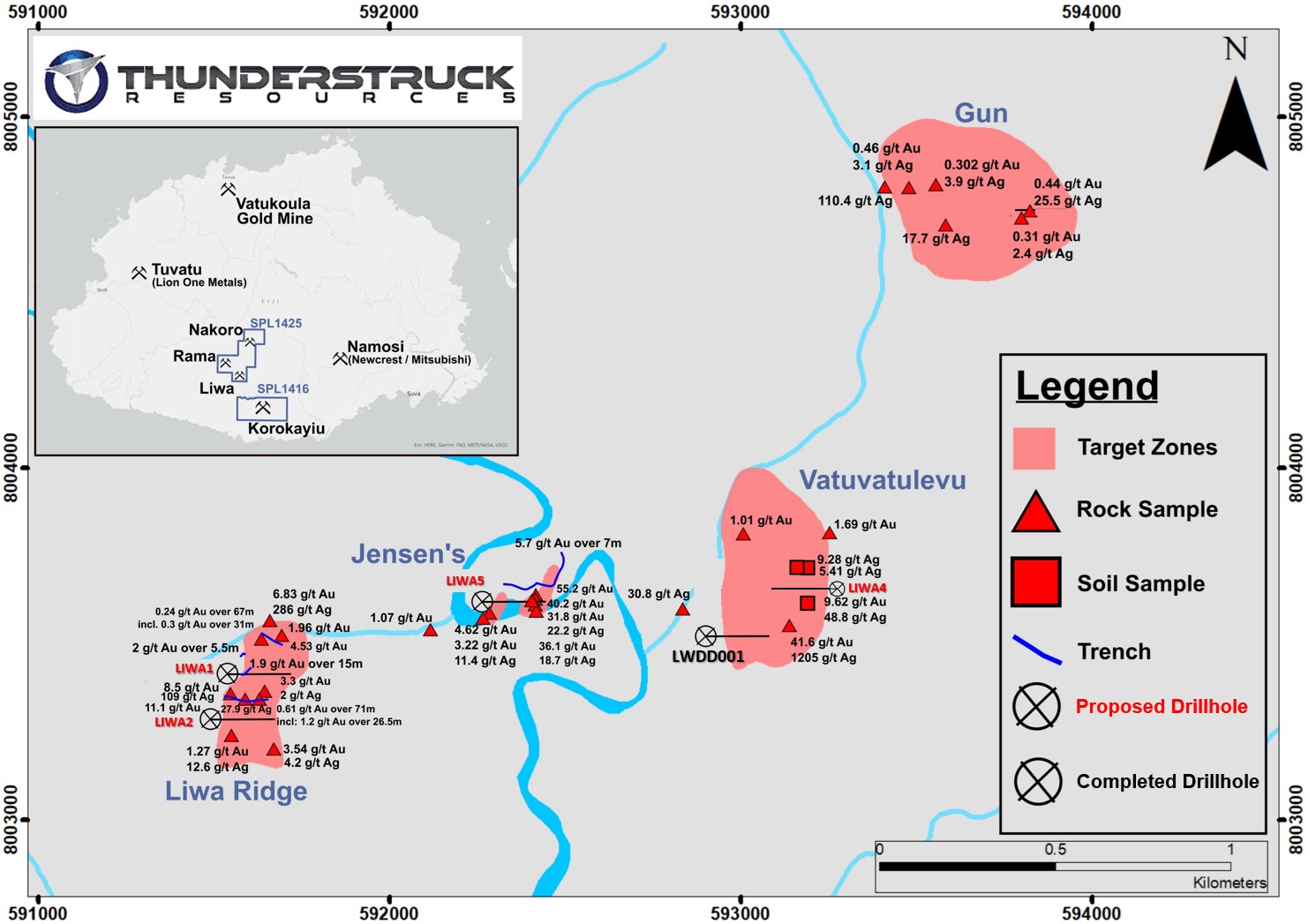
Multiple drill targets across four targets have been defined by coincident surface gold and copper with induced polarization resistivity anomalies at depth, including two exploratory drill holes at Jensens and Lower Vatuvatulevu (Figure 4). The Cu/Au porphyry potential of Gun Prospect requires a comprehensive program focused on exploring its significant potential as it relates to its porphyry neighbours at Thunderstruck’s Rama and Newmont’s Namosi.
Figure 4: Liwa past exploration highlights and proposed future drill hole location.


